Glendale's Dams, Ponds and Bridges
Story furnished by Clarence Crocker
In looking for info regarding Glendale’s dams, pond and bridges, I found and purchased copies of two plats* at the Spartanburg County Registrar Means Conveyance office which I found interesting and germane to my search. One plat dated September 27, 1803 and another dated December 29, 1804 shows the upper and lower shoals on Lawson's Fork. Neither shows a pond or bridge at either of the shoals. Only the old Georgia road which ran across Lawson's Fork at the upper shoals is shown without any reference to a bridge. The 1803 plat shows dots across the lower shoals which perhaps indicate a horse and wagon crossing by forging the creek. One of the land purchase deeds of Dr. Bivings which I will be reporting in a forthcoming article, refers to a wagon road which perhaps speaks of the same.
A map of Spartanburgh (Original name of Spartanburg) District dated 1825 which I have seen as well as a 1887 map of Spartanburg county, shows the old Georgia road passing the Bagwell farm and Doctor Walker’s home (who was one of Glendale’s Doctors) crossing Lawson's Fork about a half mile above where the mill was later built, curving south, touching the northern edge of the future Glendale mill village, continuing northeastward to intersect with the Spartanburg/Charlotte highway. Incidentally, the map shows that Dr. Russell, also a Glendale Doctor, lived a short way up the creek from Dr. Walker. (Read more at Medical Care.)
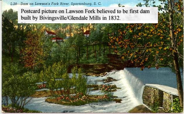
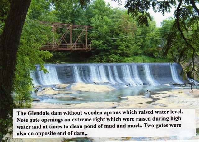
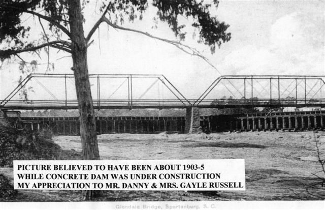
With these records, as best as I have been able to determine, there was neither a dam, pond or bridge in the mill/village area of Bivingsville/Glendale until after the construction of The Bivingsville Mfg. Company. (1832-35) (Read more at Glendale Mill Story) A rock dam was built by Dr. Bivings to provide sufficient continuous water supply for the large water wheel which supplied energy for mill operations. The dam was built on the lower shoals just below where the present concrete dam now stands. The rock dam failed during the flood of 1903 and was replaced by the concrete dam. (Read more at Lawson's Fork Flood).
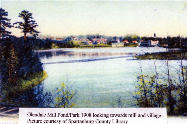
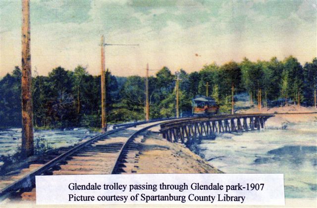
For over a hundred years the Glendale Mill pond had been a source of fun, frolic and food. The Glendale Park which was built on the pond by the South Carolina Gas and Electric Co. in the early 1900s, was called “The Wood’s Park” by local residents. Visitors to the park traveled a narrow dirt road from the village which ran along side of the creek to the Park area. Mr. Jervey DuPre who was with the Mill at that time, later becoming President, tells us in one of his interviews that on the week ends and holidays, the park was filled with visitors. Though it was a popular spot and frequented by visitors from far and wide in the early 1900s when it was in full swing, no real marks of the park’s existence remains today.
Frozen over in the winter time, the pond furnished a huge ice skating ring to the delight of all willing to dare its danger. In the hot days of summer, a few boats with their occupants basking in the sun, could be seen floating along the still water and yes, some were swimming. Hundreds, perhaps thousands of pounds of fish have been pulled from it’s waters to be eaten. A few would be seen fishing from the bridge walkway while occasionally, when Mr. Will Quinn the village policeman (Read more at Glendale Police.) wasn’t around, a teenage boy would dare climb and walk the top rails of the bridge.
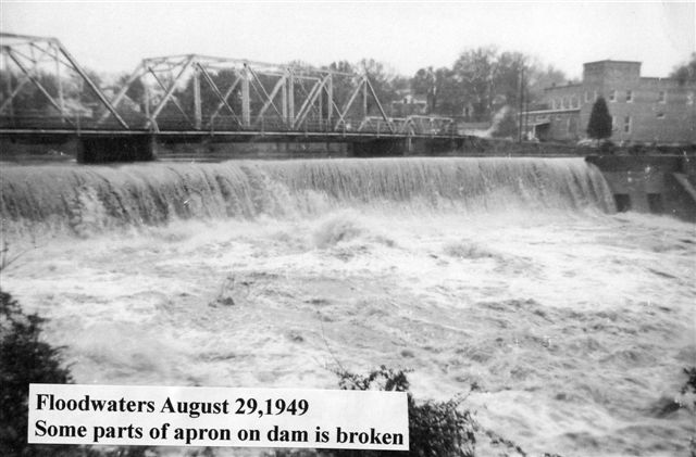
The pond which was once vital to the village, it’s industry and the well being of it’s residents, is not near so deep or large as it once was. Trees, vegetation, silt, logs, parts of the old wooden dam along with the removal of the aprons have all contributed to the reduction of the pond in size and depth. Except for an occasional rainy season resulting in flash floods, the pond is normally quite and peaceful with it’s white water overflowing the dam making it’s bank an ideal place of repose and reflection.
The above picture shows the first bridge of which I have any record crossing the waters of the Bivingsville/Glendale Mill Pond on Lawson's Fork creek. Constructed sometime in the 1800s, it was a single lane steel girder/truss, untreated wood floor structure and was located on the stream where the present iron bridge stands today. Pedestrians across the pond from the mill walking to or from the post office, mill store, doctor’s office, mill and village walked with the traffic crossing the bridge. There were some foot bridges which crossed the stream behind the mill for employees from Gobblers Knob, Sutton Springs and Bethesda road to walk over, coming to and going from work, if they so desired.
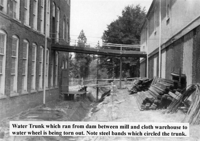
The temporary wooden dam shown in the foregoing picture, was built following the failure of the old rock dam in order to construct the new concrete dam which stands today. Note the curve on the right side of the wooden dam which protrudes under the bridge. Water from this point flowed into a sluice carrying water to the mill’s water wheel located on the lower end of the mill plant. After the new dam was completed, a huge treated wood tunnel called “the trunk” was built through which the water to the wheel flowed, eliminating the open water sluice which flowed under the steps entering Plant #3 and under the floors of Plant #2. As I remember, the inside diameter of the trunk was about six feet.
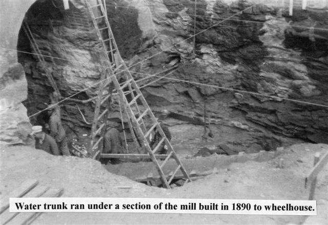
I shall never forget the first time when as a young boy, (about 10 or 12) I went down to the wheel house with my cousin John T. Varner Jr. whose dad, J. Taylor Varner Sr. was Mill Master Mechanic when the dam and trunk were built. The water was roaring out of the trunk like Niagara Falls, the water wheel was churning and the water around it was turbulent and looked angry to say the least. It was a frightful sight. To tell you the truth, I remember being scared half to death!
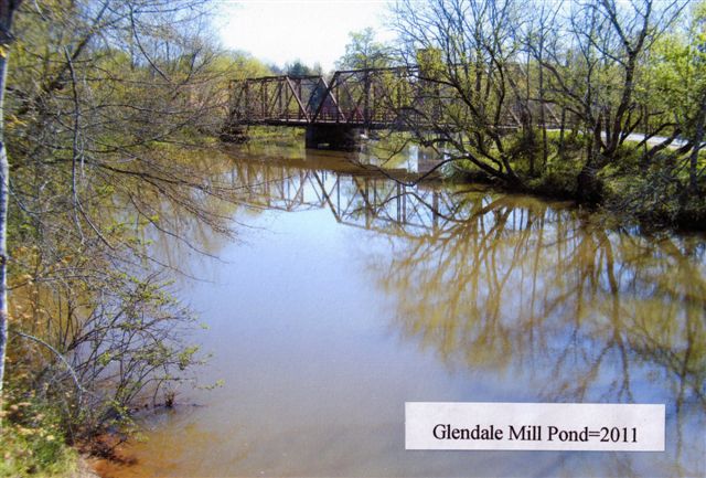
The first iron bridge shown above was replaced around 1928 with sections being used later to span Lawson's Fork about 2 miles downstream from the mill on the Thompson farm road which connected the Thompson “ford” road (now Lewis Chapel/Goldmine road) with the Glendale/Bethesda road (now Emma Cudd Road) just below the Bethesda Baptist Church. The road has long since been closed but the bridge structure still stands. Incidentally, my understanding is that when old roads had the word “ford” attached, it indicated no bridge and that the steam had to be forded.
A new much stronger two lane steel girder/truss, treated wood floor bridge replaced the old one lane bridge about 1928. The new bridge provided a pedestrian walkway on the right side entering the village allowing pedestrians to cross the pond without walking in the road way with traffic. I understand that the new bridge was raised slightly higher above the water than the old bridge.
According to a news announcement in the Spartanburg Herald on August 16, 1933, the bridge was to be closed for three or four days while the floor of the bridge was being surfaced treated. The Glendale/Clifton road had been surfaced treated for the first time the year before. (Read more at Paving of Glendale Clifton Highway). Henry E. Wofford, Spartanburg County Supervisor reported that suitable detours had been mapped for the route. The program was launched to protect the expensive timbers used in the bridge construction. He stated that the treated timbers used in the bridge construction cost about twice the price of ordinary timbers used in previous construction and if the wood is protected by surfacing, the bridge floor would last indefinitely.
The County having relinquished the C30 road (Glendale/Clifton) and bridge to the State Highway Department for supervision and maintenance some years earlier, the State Highway Department on Saturday January 17, 1976 announced in the Spartanburg Herald and Journal that a public meeting would be held in the Glendale Elementary School cafeteria at 3 P.M. for the purpose of discussing the proposed design and location of a new bridge to replace the old steel/wood structure. Related maps, drawings and other pertinent data was to be made available for inspection and copying.
The approach to the new bridge was to run straight from the curve at the bottom of Highland Street’s exit across the pond to connect straight into the Glendale/Whitestone road. This would eliminate the two dangerous curves around by the store in the approach to the old bridge. It would also bypass the congested business/post office area and the danger in the dip in the road in front of the stores on the opposite side of the river from the mill. Tentative schedules for right of way acquisitions and construction were to be discussed. Assistance for displaced persons or businesses was also to be discussed and outlined.
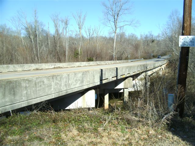
Present Day Bridge
With all plans of the project approved and on “go” Saturday November 6, 1976, the S.C. Highway department announced in the Spartanburg Herald and Journal that a contract for the construction of the bridge and relocation of the road had been granted. Based on the lowest bid, the Copeland Construction Co. of Orangeburg, S.C. was granted the contract. The contract called for the construction of a 250 foot reinforced concrete bridge over the Lawson Fork Creek mill pond and asphalt concrete surfacing of .521 mile of approaches on Road S30 east of Spartanburg. The contract was in the amount of $303,831 and allowed 230 days for completion of the project.

Today, the old iron bridge, though in bad disrepair, remains over the waters of the mill pond as a pedestrian walkway. The original wood floor pedestrian walkway has rotted out completely. After the fire which destroyed the Glendale Mill plants and other related buildings, the mill office and some surrounding land area were given to Wofford College of Spartanburg, S. C. They have already completed a beautiful job in the restoration of the mill office and the surrounding grounds. It is my understanding that plans are to restore and install lights on the bridge that it too might become another focal point of interest and a place for community meetings, of which the residents can be proud.
Click on this link The Mud Bridge for more information about an often unnoticed Glendale Bridge.
Ode to the Old Mill Pond:
City dwellers seeking rest, Came to the Old Mill Pond, it was the best. May this old pond for years to come, bring peace, joy and precious memories to everyone! Author unknown.
*References; Plat 77 recorded in Book A page 77, October 3, 1803, Spartanburg Registrar’s Book of Deeds for W. R. Smith. Plat 153 recorded in Book A page 153, December 29, 1804, Spartanburg Registrar’s Book of Deeds for Charles Mathews. Newspaper copies from Micro Film Dept. of Spartanburg County Library.

This web site has been started as a public service to share the story of Glendale. See more information about Mary and her Glendale connection at Mary McKinney Teaster.